Skip to content
Monday, August 18, 2025

NAP Readiness Project

NAP Readiness Project

  • About
    • About Project
    • Consultants
      • National
      • International
    • Partners
  • Activities
    • Federal Activities
    • States Activities
  • Documentation Library
    • Reports
    • Maps and Figures
    • Related Studies
  • Gallery
  • State Level
    • West Kordofan
    • South Kordofan
    • North Kordofan
    • El Gaziera
  • M&E
  • Contact Us
You are Here
  • Home
  • 2025
  • August
  • 4
  • Fig 6b Poverty Hotspot Map in Kassala State Kassala
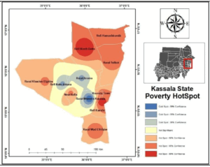
Maps and Figures Poverty Distribution and Hotspot Maps

Fig 6b Poverty Hotspot Map in Kassala State Kassala

Post navigation

Fig 6a Poverty Distribution in Kassala State Kassala
Fig 7a Poverty Distribution in Gedaref State Gadarif
    All Rights Reserved 2025.
    Proudly powered by WordPress | Theme: Refined Blocks by Candid Themes.