Skip to content
Monday, August 18, 2025

NAP Readiness Project

NAP Readiness Project

  • About
    • About Project
    • Consultants
      • National
      • International
    • Partners
  • Activities
    • Federal Activities
    • States Activities
  • Documentation Library
    • Reports
    • Maps and Figures
    • Related Studies
  • Gallery
  • State Level
    • West Kordofan
    • South Kordofan
    • North Kordofan
    • El Gaziera
  • M&E
  • Contact Us
You are Here
  • Home
  • 2025
  • August
  • 4
  • Fig 2.b Flood Hotspot in Northern State The Northern
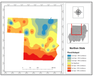
Floods Risks and Floods Hotspot Maps Maps and Figures

Fig 2.b Flood Hotspot in Northern State The Northern

Post navigation

Fig 2.a Flood Risk in Northern State The Northern CONSTRUCTING CLIMATE CHANGE VULNERABILITY HOTSPOT MAPS (SPECIFIED IN LOA) FLOOD RISK & HOTSPOT FINAL REPORT PREPARED FOR FAO- SUDAN BY THE FACULTY OF GEOGRAPHICAL AND ENVIRONMENTAL SCIENCES UNIVERSITY OF KHARTOUM OCTOBER, 2024
Fig 3.a Flood Risk in River Nile State The River Nile
    All Rights Reserved 2025.
    Proudly powered by WordPress | Theme: Refined Blocks by Candid Themes.