Skip to content
Monday, August 18, 2025

NAP Readiness Project

NAP Readiness Project

  • About
    • About Project
    • Consultants
      • National
      • International
    • Partners
  • Activities
    • Federal Activities
    • States Activities
  • Documentation Library
    • Reports
    • Maps and Figures
    • Related Studies
  • Gallery
  • State Level
    • West Kordofan
    • South Kordofan
    • North Kordofan
    • El Gaziera
  • M&E
  • Contact Us
You are Here
  • Home
  • 2025
  • August
  • 4
  • Fig 18b Poverty Hotspot Map in Blue Nile State The Blue Nile
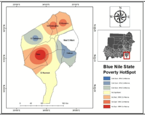
Maps and Figures Poverty Distribution and Hotspot Maps

Fig 18b Poverty Hotspot Map in Blue Nile State The Blue Nile

Post navigation

Fig 18a Poverty Distribution in Blue NileState The Blue Nile
Climate Governance in Eastern Africa: The Challenges and Prospects of Climate Change Adaptation Policies
    All Rights Reserved 2025.
    Proudly powered by WordPress | Theme: Refined Blocks by Candid Themes.