Skip to content
Tuesday, February 10, 2026
NAP Readiness Project
NAP Readiness Project
About
About Project
Consultants
National
International
Partners
Activities
Federal Activities
States Activities
Documentation Library
Reports
Maps and Figures
Related Studies
Gallery
State Level
West Kordofan
South Kordofan
North Kordofan
El Gaziera
M&E
Contact Us
Search for:
You are Here
Home
2025
August
4
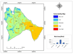
Fig 18.a Flood Risk in Sennar State Sennar
Floods Risks and Floods Hotspot Maps
Maps and Figures
Fig 18.a Flood Risk in Sennar State Sennar
Post navigation
Fig 17.b Flood Hotspot in West Kordofan state West Kordofan
Fig 18.b Flood Hotspot in Sennar State Sennar